
LIBRO INGLESE
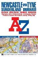
Newcastle upon Tyne A-Z Street Atlas (paperback)
6,62 €

-50%
13,24 €
+70
punti Prezzo minimo ultimi 30 giorni: 4,63 €
Venditore: Feltrinelli
Articolo acquistabile con Carta del Docente

Articolo acquistabile con Carta Cultura Giovani e Carta del Merito

Dati e Statistiche
 Salvato in 0 liste dei desideri
Newcastle upon Tyne A-Z Street Atlas (paperback)
Disponibilità immediata
6,62 €
-50%
13,24 €
6,62 €
13,24 €
-50%
Disp. immediata


This A-Z map of Newcastle upon Tyne includes coverage of Sunderland, Durham, Gateshead, South Shields, Tynemouth and Washington. There are 154 pages of continuous street mapping extending to: *Bedlington *Blaydon *Blyth *Chester-le-Street (part) *Darras Hall *Ryton *Seaham *Stanley *Whitley Bay In addition, there is separate coverage of Peterlee, Easington and Horden and large scale city centre maps of Newcastle upon Tyne, Sunderland and Durham. Postcode districts, one-way streets and safety camera locations with maximum speeds are featured on the street mapping. The index section lists streets; selected flats, walkways and places of interest; place and area names; National Rail and Tyne & Wear Metro Stations. There is a separate list of hospitals and hospices covered by this publication. A Tyne & Wear Metro and Rail Connections map is included on the back cover.
-
Autore:
-
Editore:
-
Anno:2017
-
Rilegatura:Paperback / softback
-
Pagine:288 p.
Testo in English
Dimensioni:
192 x 129 mm
Peso:
340 gr.
EAN:
9781782571315
Informazioni e Contatti sulla Sicurezza dei Prodotti
Le schede prodotto sono aggiornate in conformità al Regolamento UE 988/2023. Laddove ci fossero taluni dati non disponibili per ragioni indipendenti da Feltrinelli, vi informiamo che stiamo compiendo ogni ragionevole sforzo per inserirli. Vi invitiamo a controllare periodicamente il sito www.lafeltrinelli.it per eventuali novità e aggiornamenti.
Per le vendite di prodotti da terze parti, ciascun venditore si assume la piena e diretta responsabilità per la commercializzazione del prodotto e per la sua conformità al Regolamento UE 988/2023, nonché alle normative nazionali ed europee vigenti.
Per informazioni sulla sicurezza dei prodotti, contattare productsafety@feltrinelli.it