
LIBRO INGLESE
Historical Map of Ireland
24,99 €
+250
punti 
Venditore: Feltrinelli
Articolo acquistabile con Carta del Docente

Articolo acquistabile con Carta Cultura Giovani e Carta del Merito

Articolo acquistabile con Carta della Cultura

Dati e Statistiche
 Salvato in 0 liste dei desideri
Historical Map of Ireland
Disponibile in 5 gg lavorativi
24,99 €
24,99 €
Disponibile in 5 gg lavorativi
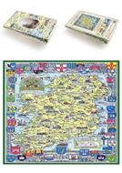

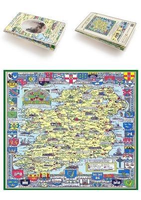
This folded map (890mm x 1000mm) pictorially illustrates the history of Ireland. With historical locations and events illustrated pictorially in the form of charming cartoon vignettes, the map is surrounded by the armorial crests of Ireland. The map was drawn by Leslie Bullock and first published in 1963 by Collins Bartholomew as a fold-up map. This popular map from its time has now been re-digitized and republished in association with the Collins Bartholomew Archive using the latest printing technology. The print media used is 90 gsm "Progeo" paper which was specially developed as a map paper. It has high opacity to help reduce show through and a cross grain giving it greater durability to as the map is being folded.
-
Editore:
-
Collana:Historical Great Britain Collection
-
Anno:2019
-
Rilegatura:Paperback / softback
Pagine:
1 p.
Testo in English
Dimensioni:
227 x 134 mm
EAN:
9781844918492
Informazioni e Contatti sulla Sicurezza dei Prodotti
Le schede prodotto sono aggiornate in conformità al Regolamento UE 988/2023. Laddove ci fossero taluni dati non disponibili per ragioni indipendenti da Feltrinelli, vi informiamo che stiamo compiendo ogni ragionevole sforzo per inserirli. Vi invitiamo a controllare periodicamente il sito www.lafeltrinelli.it per eventuali novità e aggiornamenti.
Per le vendite di prodotti da terze parti, ciascun venditore si assume la piena e diretta responsabilità per la commercializzazione del prodotto e per la sua conformità al Regolamento UE 988/2023, nonché alle normative nazionali ed europee vigenti.
Per informazioni sulla sicurezza dei prodotti, contattare productsafety@feltrinelli.it