
LIBRO INGLESE
Imray Chart G36 Turkey - South Coast: Marmaris to Kekova Adasi
29,94 €
+300
punti 
Venditore: Feltrinelli
Articolo acquistabile con Carta del Docente

Articolo acquistabile con Carta Cultura Giovani e Carta del Merito

Articolo acquistabile con Carta della Cultura

Dati e Statistiche
 Salvato in 0 liste dei desideri
Imray Chart G36 Turkey - South Coast: Marmaris to Kekova Adasi
Disponibile in 5 gg lavorativi
29,94 €
29,94 €
Disponibile in 5 gg lavorativi
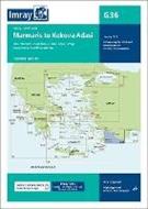
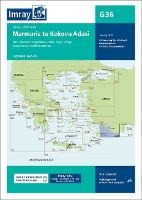
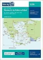
Plans included: Marmaris Limani (1:50 000) Skopea Limani (1:100 000) Goecek (1:25 000) Fethiye (1:35 000) Approaches to Kastellorizo and Kas (1:75 000) Imray-Tetra charts for the Ionian and Aegean are widely acknowledged as the best available for the cruising sailor. They combine the latest official survey data with first-hand information gathered by Rod and Lucinda Heikell. The chart is designed to be used alongside Imray pilot guides of the area. Like all Imray charts, they are printed on water resistant Pretex paper for durability, and they include many anchorages, facilities and inlets not included on official charts. This edition includes the latest official data combined with additional information sourced from Imray's network to make it ideal for small craft. The latest harbour developments at Goecek are included as is latest official bathymetric survey data. There has been general updating throughout.
-
Autore:
-
Editore:
-
Collana:Imray G Charts
-
Anno:2022
-
Rilegatura:Sheet map, folded
Pagine:
1 p.
Testo in English
EAN:
9781786793539
Informazioni e Contatti sulla Sicurezza dei Prodotti
Le schede prodotto sono aggiornate in conformità al Regolamento UE 988/2023. Laddove ci fossero taluni dati non disponibili per ragioni indipendenti da Feltrinelli, vi informiamo che stiamo compiendo ogni ragionevole sforzo per inserirli. Vi invitiamo a controllare periodicamente il sito www.lafeltrinelli.it per eventuali novità e aggiornamenti.
Per le vendite di prodotti da terze parti, ciascun venditore si assume la piena e diretta responsabilità per la commercializzazione del prodotto e per la sua conformità al Regolamento UE 988/2023, nonché alle normative nazionali ed europee vigenti.
Per informazioni sulla sicurezza dei prodotti, contattare productsafety@feltrinelli.it