LIBRO INGLESE
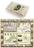
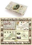
Cornwall 1611 - 1836 - Fold Up Map that features a collection of Four Historic Maps, John Speed's County Map 1611, Johan Blaeu's County Map of 1648, Thomas Moules County Map of 1836 and Robert Dawson's Reform Act Plan of Truro 1831. The maps are surrounded by Cornwall's Historic Buildings.
24,99 €
+250
punti 
Venditore: Feltrinelli
Articolo acquistabile con Carta del Docente

Articolo acquistabile con Carta Cultura Giovani e Carta del Merito

Dati e Statistiche
 Salvato in 0 liste dei desideri
Cornwall 1611 - 1836 - Fold Up Map that features a collection of Four Historic Maps, John Speed's County Map 1611, Johan Blaeu's County Map of 1648, Thomas Moules County Map of 1836 and Robert Dawson's Reform Act Plan of Truro 1831. The maps are surrounded by Cornwall's Historic Buildings.
Disponibilità in 5 giorni lavorativi
24,99 €
24,99 €
Disp. in 5 gg lavorativi


-
Autore:
-
Editore:
-
Collana:Historic Counties Map Collection
-
Anno:2014
-
Rilegatura:Sheet map, folded
Pagine:
1 p.
Testo in English
Dimensioni:
237 x 134 mm
EAN:
9781844918256
Informazioni e Contatti sulla Sicurezza dei Prodotti
Le schede prodotto sono aggiornate in conformità al Regolamento UE 988/2023. Laddove ci fossero taluni dati non disponibili per ragioni indipendenti da Feltrinelli, vi informiamo che stiamo compiendo ogni ragionevole sforzo per inserirli. Vi invitiamo a controllare periodicamente il sito www.lafeltrinelli.it per eventuali novità e aggiornamenti.
Per le vendite di prodotti da terze parti, ciascun venditore si assume la piena e diretta responsabilità per la commercializzazione del prodotto e per la sua conformità al Regolamento UE 988/2023, nonché alle normative nazionali ed europee vigenti.
Per informazioni sulla sicurezza dei prodotti, contattare productsafety@feltrinelli.it